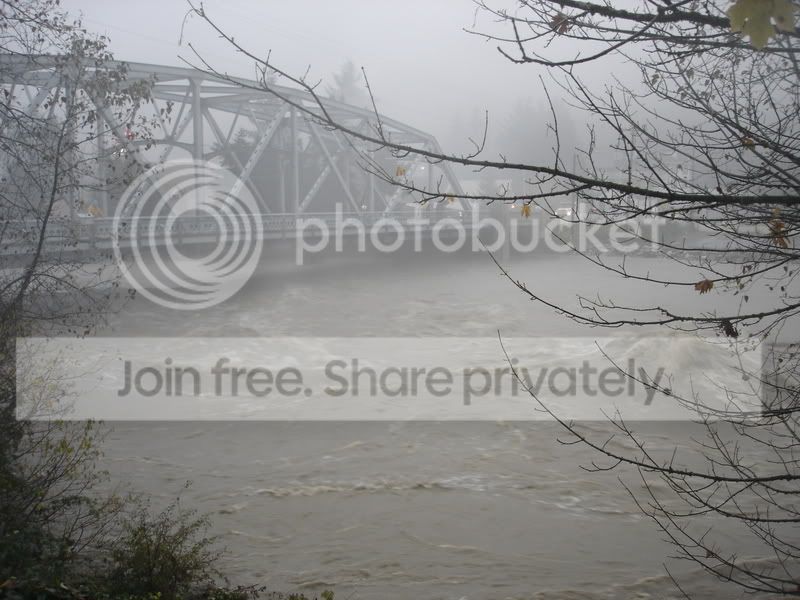
Some Flood Pictures (more pictures by others and myself)


Thread Starter
Senior Member
Club One

SL Member
Joined: May 2006
Posts: 3,583
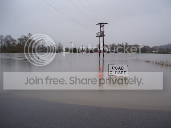
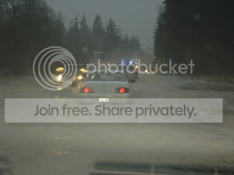
Road Closed... really?

So, see the water coming over the bank? The water is coming from a slough thing which oddly doesn't correspond with the Stilliguamish which is just a mile away. We came back to this spot about a half hour later and the whole bank had water going over it, it had flooded the entire field and then was covering the entire road, going on into the next field which was filling up at an amazing rate. After that field, the only other place to go is downtown Stanwood.

This house is on the bank I described earlier. The water was just rushing through their yard. I wonder what it looks like now?
We'll have to go all the way around, the long way, to Stanwood and see what's doing with those fields, in a few hours. I won't be able to get anywhere near it now. Infact, when we saw how fast the fields were filling up, we got out ASAP.

Senior Member
SL Member
Joined: Sep 2006
Posts: 978
From: Indianapolis, IN
Originally Posted by Jenna
Road Closed... really?
I work up in Burlington, but I live in Oak Harbor. I'm sorry for all of you that have had to deal with this sh*t moving down south. We were supposed to get it all up here but we didn't. I don't know if Burlington got anything bad last night.. but I know they closed 20 beteween Burlington and Sedro-Wooley. The sucky thing is.. if they had to close 20 between Burlington and Oak Harbor, I'd be a) stranded {likely} or b) going the super long way around. That would mean like.. catching the Whidbey Island ferry (provided it ran as late as I work) or going even more down south and around. Crappy!
Oh well.. hope everybody is doing alright.
Thread Starter
Senior Member
Club One
SL Member
Joined: May 2006
Posts: 3,583
We saw quite a bit of those idiots yesterday but this road goes on to endless, deep flooding, lol.
The river in Burlington/Mt. Vernon isn't due to crest just yet but is still predicted to hit record levels.
The river in Burlington/Mt. Vernon isn't due to crest just yet but is still predicted to hit record levels.
Senior Member
SL Member
Joined: Sep 2006
Posts: 978
From: Indianapolis, IN
Originally Posted by Jenna
We saw quite a bit of those idiots yesterday but this road goes on to endless, deep flooding, lol.
The river in Burlington/Mt. Vernon isn't due to crest just yet but is still predicted to hit record levels.
The river in Burlington/Mt. Vernon isn't due to crest just yet but is still predicted to hit record levels.


They were talking about having to close the road between Camano Island and the rest of the world or "mainland" as they call it, scarry I remember in '96 when the snohomish river valley flooded...whatta mess!
Thread Starter
Senior Member
Club One
SL Member
Joined: May 2006
Posts: 3,583
Originally Posted by CLAPhoto
Thanks. It's right behind where I work (Fred Meyer).. so we're all just kinda waiting.
So what department do you work in? I sometimes go to Freddy's. If you ever see a blond fat chick, yelling at her 3 blond male children while in there... that's me!
CoreyAnn... thanks. I'm not too impressed with them though. Not catastrophic enough, lol.
Senior Member
SL Member
Joined: Sep 2006
Posts: 978
From: Indianapolis, IN
Originally Posted by Jenna
Originally Posted by CLAPhoto
Thanks. It's right behind where I work (Fred Meyer).. so we're all just kinda waiting.
So what department do you work in? I sometimes go to Freddy's. If you ever see a blond fat chick, yelling at her 3 blond male children while in there... that's me!
CoreyAnn... thanks. I'm not too impressed with them though. Not catastrophic enough, lol.
I work in Electronics. My name tag is currently temporary because I misplaced mine.. it says "Ariane
 " and underneath that it says, "Home Electronics Only!!" Haha. That'd be me.
And I undertsand where you're coming from on the pictures, haha. I took pictures of my damaged Honda and was like, "They don't make it look as bad as it is! How do I make them look as bad as it is?!?" But your pictures do look it's serious, that's for sure.
Thread Starter
Senior Member
Club One
SL Member
Joined: May 2006
Posts: 3,583
Originally Posted by Kanchi
They were talking about having to close the road between Camano Island and the rest of the world or "mainland" as they call it

Senior Member

SL Member
Joined: Apr 2006
Posts: 3,036
From: South Bay, CA & South Sound, WA (Dual Resident)
Hahaha...I love the chaos of being cut off from society and having to "hole up" inside. That's what my family home is like. That snowstorm of '95 we had to hike out (over a foot of snow) and walk for miles just to get wood because our power was out for days.
Senior Member
SL Member
Joined: Sep 2006
Posts: 978
From: Indianapolis, IN
Originally Posted by Jenna
Originally Posted by Kanchi
They were talking about having to close the road between Camano Island and the rest of the world or "mainland" as they call it

Senior Member
SL Member
Joined: Aug 2006
Posts: 474
From: Kent, WA
The Snoqualmie river crested 60'. Thats 5+' above flood stage. And thats the Carnation area. I hear Goldbar/Sultan, up there the river is 1' under the bridges. Normally has.....oh say.....12+' of clearance.

Senior Member
SL Member
Scion Evolution
Joined: Oct 2004
Posts: 7,067
From: PNW
thats ok.. i saw a pansy h2 driver change lanes to avoid a water that was covering 3/4 of a lane less than 1ft deep at most... and he had a snorkel on it...
now pedestrains in site to worry about splashing
now pedestrains in site to worry about splashing
Thread Starter
Senior Member
Club One
SL Member
Joined: May 2006
Posts: 3,583
Originally Posted by CLAPhoto
And I undertsand where you're coming from on the pictures, haha. I took pictures of my damaged Honda and was like, "They don't make it look as bad as it is! How do I make them look as bad as it is?!?" But your pictures do look it's serious, that's for sure.
Thread Starter
Senior Member
Club One
SL Member
Joined: May 2006
Posts: 3,583
CLAphoto...
http://ahps2.wrh.noaa.gov/ahps2/hydr...ew=1,1,1,1,1,1
This should help you in your river tracking. Everybody can use it... just search for the right river.
http://ahps2.wrh.noaa.gov/ahps2/hydr...ew=1,1,1,1,1,1
This should help you in your river tracking. Everybody can use it... just search for the right river.

Thread Starter
Senior Member
Club One
SL Member
Joined: May 2006
Posts: 3,583
Originally Posted by Gsnorgathon
Originally Posted by Jenna
Road Closed... really?
I took much better pictures tonight... just too tired to resize and upload them at the moment. The area really ended up flooding nicely, lol. I even have some shots of like 6 kids taking a canoe out on the flooded fields, lol.
And the worms... omg, these worms the size of snakes were crawling everywhere. Guess when it floods, they'll come out and play.